The best hikes in Colombia for out-of-this-world adventures
-
 Loading...
 - Vanessa Davis
- 15 Mar 2022
- 392 Views
- 0 Like
- 0 Comment
Following decades of conflict concentrated in rural areas, the demobilization of rebel groups has finally paved the way for access to trails in some of Colombia’s remotest outposts. While some trails are signposted, others are not, so hiking in Colombia safely often requires the assistance of a local guide, whose knowledge of the fragile ecosystems and indigenous customs are invaluable additions.
Getting out onto the trails is a way of seeing Colombia in a new light. It isn’t just a place of vivacious cities and infectious rhythms, but a country home to enchanting archeological sites, rare endemic wildlife and dizzyingly high-altitude scenery.
Ciudad Perdida Trek
Best hike to an archeological site
40km (24.8 miles) round trip, 5 days, moderate
Hikers of all stripes gravitate to the Ciudad Perdida (Lost City) trek, Colombia's most mystical trail. This epic route is the country’s answer to the Inca Trail, but where Peru’s legendary mountaintop fortress teems with tourists, the lost city hidden away in Colombia's Sierra Nevada de Santa Marta mountain range sees just a handful of visitors.
It helps that the former stronghold of the Tairona people can only be reached by a five-day trek, discouraging fair-weather hikers. It’s a steep, sweaty and sometimes grueling slog through seemingly impenetrable jungle, although crystalline swimming holes and hammocks slung with mosquito nets make for welcome stops en-route.
Early on day four, a flight of 1200 stone steps delivers you to the silent grounds of this 32-hectare city, where tendrils of jungle still cling to the remarkably preserved remains of circular stone terraces, plazas and storehouses once used by a population of more than 4000 people.
You can only reach the Ciudad Perdida as part of an organized trek, so arrange your tour in Santa Marta. All trekking companies and guides are local, ensuring your money flows directly back into the communities you pass through along the way.
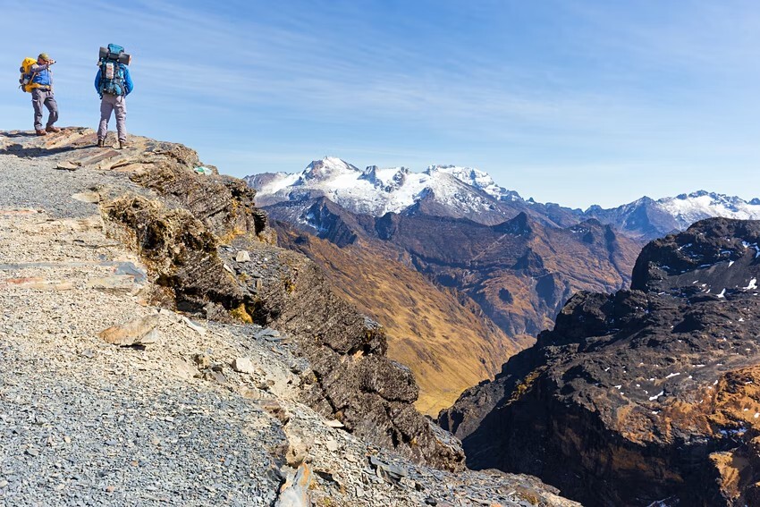
Nevado del Tolima summit
Best high-altitude hike
58.5km (36.3 miles) round trip, 4 days, challenging
Snowy peaks might be an unexpected sight in the tropics, but that's what you'll find in Parque Nacional Natural Los Nevados. A cluster of 5000m (16,400ft) volcanic peaks rising from the lush hillsides of Colombia’s main coffee region, the park attracts trekkers and mountaineers from around the world, keen to conquer its challenging high-altitude terrain.
At 5200m (17,060ft), Nevado del Tolima is the second tallest volcano here and the most rewarding peak to climb. However, the approach to the summit is a challenging and technical ascent, covering 58.3km (36.3 miles) and only suitable for those with previous mountaineering experience. Ropes, ice axes, harnesses and crampons are needed for higher sections.
Starting in the Valle Cocora, the hike climbs steeply through the park’s trademark landscape of Quindío wax palms before the scenery transitions into the uniquely Andean ecosystem known as paramo. This grassy shrubland is dotted with spiky, slow-growing frailejón plants, said to resemble the silhouette of a hooded monk.
Higher still, glassy lakes, glaciers and views of the perfectly conical crater of Tolima add to the sense of adventure as you struggle up to the summit. Having conquered Tolima, admire the views towards the gently smoking tip of highly active Volcán Ruiz, the park’s tallest peak, and soak up the majesty of the experience.
For a gentler introduction to the park, consider the three-day trek up to the snowline at around 4600m (15,091ft). You’ll miss the thrilling final ascent but will be spared the need to bring climbing ropes, ice axes and other technical gear. To avoid the heaviest rainfall, hike in January or February, but note that poor weather is a possibility year-round – trekking poles are highly recommended.
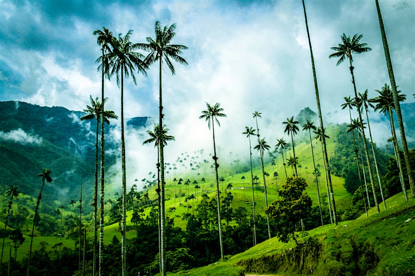
Cocora Valley Hike
Best hike for whimsical landscapes
15km (9 miles) round trip, 6 hours, moderate
Parque Nacional Natural Los Nevados might be dominated by its volcanic summits, but there’s plenty of less challenging terrain to engage hikers here. Reached by the iconic Willy Jeeps that rumble between Valle Cocora and the town of Salento, the park’s most acclaimed day hike clambers up onto hillsides that offer picture-perfect views over the whimsical Quindío wax palms that dot practically every inch of land.
Stop for a breather and a photo opportunity at the Acaime La Casa de Los Colibríes (a hummingbird sanctuary), but save some memory card space for shots of the palms themselves, which grow up to 60m (200ft) tall and end with a sparse cluster of leaves at their tops, like trees in a Dr Seuss book. Keep your eyes on the skies, too – the national park is an important habitat for the endangered yellow-eared parrot.
Puracé Volcano
Best active volcano hike
14km (8.6 miles) round trip, 7 hours, challenging
Lying in the far south of Colombia, Parque Nacional Natural Puracé is one of the country’s less-visited parks, but its snow-dappled volcanoes and desolate paramo plains rise to the jagged spine of the Andes Mountains. This is also one of the last haunts of the Andean condor.
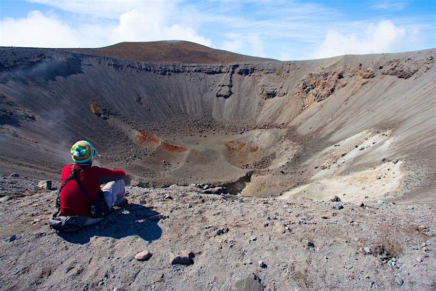
For intrepid adventurers, the hike to Volcán Puracé is the epitome of off-the-beaten-path hiking. Passing through steep terrain composed of rocky outcrops and green shrubland, the route finally emerges on the edge of the deeply scooped out crater of the volcano, which measures almost 1km (0.62 miles) in diameter. The crater rim sits at 4650m (15,255ft) above sea level and this is the only active volcano hikers are permitted to climb in Colombia. From a safe distance, you can sit and watch clouds of toxic sulfur dioxide gas emerging from the crater floor.
The park lies within the community-managed Kokonuko Reserve, and you’ll need to hire the services of a local indigenous guide, all of whom are experts on the area’s topography and notoriously changeable climate. For the best conditions, start early and bring plenty of warm clothing for the top. You may need to wait for a strong gust of wind to clear the summit of clouds for views and photos.